
Montana 680 - 010-01534-10 - Garmin
- Brand: Garmin
- Product Code: 010-01534-10
- Availability: Out Of Stock
- $586.58 $690.09
- Ex Tax: $586.58
KEY FEATURES CAMERA
 GPS+GLONASS
 BIRDSEYE
 COMPASS
 BAROMETRIC ALTIMETER
Rugged GPS/GLONASS with 8 Megapixel Camera and BirdsEye Subscription
- 4-inch dual-orientation, glove-friendly touchscreen display
- 8 megapixel autofocus camera; automatically geotags photos
- Tracks both GPS and GLONASS satellites
- 1-year BirdsEye Satellite Imagery subscription
- 3-axis compass with barometric altimeter

Take it hiking. Take it hunting. Take it on the water.
Montana 680 features a dual-orientation, color touchscreen that’s glove friendly and includes a 1-yearBirdsEye Satellite Imagery subscription. The digital camera provides high-quality images, excellent resolution and automatically geotags photos with coordinates.
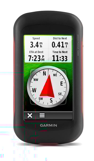
Handheld includes 3-axis tilt-compensated compass, barometric altimeter and access to both GPS and GLONASS satellites for improved positioning and typically faster fixes.
Enjoy the View
Montana 680 has a vast 4-inch, sunlight-readable touchscreen display, giving you vivid colors and high-resolution images. Its easy-to-use touchscreen means you’ll spend more time enjoying the outdoors and less time searching for information.
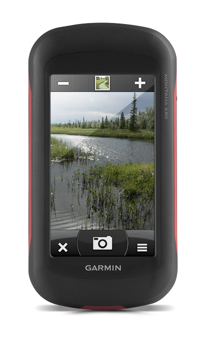
Take Geotagged Pictures
Capture locations and memories with Montana 680’s 8 megapixel digital camera. Each photo is automatically geotagged with coordinates, allowing you to navigate back to that exact spot in the future. Keep track of your photos and see their locations on a map using BaseCamp™. Insert a microSD™ card for more photo storage or to view pictures from other devices.
Mount Anywhere
With an array of compatible mounts, Montana 680 is designed for use on ATVs, in boats, as a handheld or in your car or RV. Use the auto mount with City Navigator® NT maps for spoken, turn-by-turn driving directions or the rugged mount for your motorcycle or ATV.
Go Everywhere
Adding more maps to Montana is easy. DownloadTOPO U.S. 24K maps and hit the trail, plug inBlueChart® g2 preloaded cards for a day on the water or load City Navigator map data for turn-by-turn driving directions. Add satellite images to your maps with BirdsEye Satellite Imagery (1-year subscription included). Or, transform paper maps into files you can download to your Montana with Custom Maps.
Share Wirelessly
With Montana 680, you can share your waypoints, tracks, routes and geocaches wirelessly with other compatible Garmin GPS users. Just press “send” to transfer your information to similar devices and let the games begin.
Keep Your Fix
With its high-sensitivity GPS and GLONASS reception, WAAS-enabled receiver and HotFix® satellite prediction, Montana 680 locates your position quickly and precisely and maintains it. Whether you’re in deep woods or just near tall buildings and trees, you can count on Montana 680.
Navigate with Ease
Montana 680 has a built-in 3-axis tilt-compensated electronic compass, which shows your heading even while you’re on the move or not holding it level. The barometric altimeter tracks changes in pressure to pinpoint your precise altitude, or use it to plot barometric pressure over time to help keep an eye on changing weather conditions.
Double Your Power
With a one-of-a-kind dual battery system, the 680 gives you the option of using the rechargeable lithium-ion pack or traditional AA batteries.
Find Fun
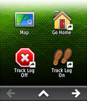
Montana 680 supports paperless geocaching GPX files for straight-to-device uploading of geocaches from Geocaching.com. No more manually entering coordinates and paper print outs, Montana stores and displays key information, including location, terrain, difficulty, hints and descriptions. The track manager feature helps organize and navigate through waypoints/routes/ and track logs (easily start/stop recording tracklogs).
Plan Your Next Trip
Our free BaseCamp software lets you view and organize maps, waypoints, routes and tracks. This free trip-planning software even allows you to create Garmin Adventures that you can share with friends, family or fellow explorers. BaseCamp displays topographic map data in 2-D or 3-D on your computer screen, including contour lines and elevation profiles.
IN THE BOX:
- Montana 680
- Lithium-ion battery pack
- USB cable
- AC charger
- Quickstart Guide
FEATURES:
Easier to Customise
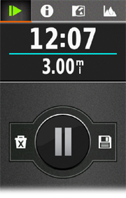 | New Track ManagerThe new Track Manager allows you to organise and navigate through waypoints, routes and track logs with ease and also provides great control over start/stop track recording. |
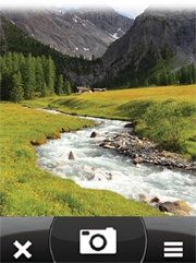 | 8 Megapixel CameraIncludes an 8 Megapixel digital camera which allows you to take images in landscape and portrait orientation. Each photo is geotagged automatically with the location of where it was taken, allowing you to navigate to that exact spot in the future. |
 | Advanced Shortcut FeaturesWhether it’s loading an application, navigating to a waypoint, switching your profile or customising specific settings to your needs, advanced shortcuts lets you combine these functions to create a custom-tailored, streamlined experience. Each Montana comes with pre-loaded shortcuts – Go Home, Track Log On/Off and Stop Navigation – to get you started. |
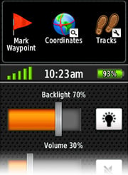 | More Dashboards in More PlacesWith 1 touch of the power button, you can pull up a multi-orientation dashboard from anywhere – your map, home screen, compass, trip computer, status page and more – so you can create more dashboards in more places. |
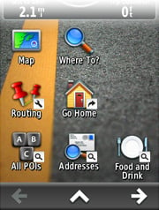 | Fully Customisable HomescreenWhether you go somewhere often, continually change settings or create shortcuts, Montana’s fully customisable home screen allows you to bring up to 16 items from "Where To?," "Setup" and "Shortcuts" to your home screen so you can easily access them without having to click between screens. |
 | Reorderable Menu OptionsReorder any menu however you like with this new feature, which keeps you from constantly scrolling to the bottom of a long list. |
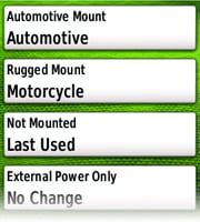 | Smarter ProfilesMontana’s smarter profiles feature remembers which profile you were using, based on the mount, so when you’re off-roading or trying to find a bike shop, it will put you in the right frame of mind so you can get you on your way quickly. |
 | Adaptable ControlsDon’t like the way something is set up? No worries. With a tap of a button, you can configure your applications easily and quickly with adaptable controls. Have to mount on the right handle bar? No problem. Montana can accommodate left- or right-handed setups based on the screen orientation. |
| Physical & Performance | |
| Camera | yes (8 megapixel with autofocus; automatic geo-tagging) |
| Weight: | 10.2 oz (289 g) with included lithium-ion battery pack; 11.7 oz (333 g) with 3 AA batteries (not included) |
| Physical dimensions | 2.9" x 5.7" x 1.4" (7.48 x 14.42 x 3.64 cm) |
| Display size, WxH | 2"W x 3.5"H (5.06 x 8.93 cm); 4" diag (10.2 cm) |
| Display resolution, WxH | 272 x 480 pixels |
| Touchscreen | Yes |
| Battery | rechargeable lithium-ion (included) or 3 AA batteries (not included); NiMH or Lithium recommended |
| Battery life | up to 16 hours (lithium-ion); up to 22 hours (AA batteries) |
| Water rating | IPX7 |
| High-sensitivity receiver | Yes |
| Barometric altimeter | Yes |
| Electronic Compass | Yes (tilt-compensated 3-axis) |
| Display type | bright, transflective 65k color TFT, dual-orientation touchscreen; sunlight readable |
| unit-to-unit transfer | Yes |
| Interface | high-speed USB and NMEA 0183 compatible |
| Garmin Connect® | |
| Garmin Connect™ compatible | Yes |
| Maps & Memory | |
| Ability to add maps | Yes |
| Accepts data cards | microSD™ card (not included) |
| Basemap | Yes |
| Built-in memory | 4 GB |
| Custom POIs (ability to add additional points of interest) | Yes |
| Preloaded street maps | Yes (some versions) |
| Routes | 200 |
| Track log | 10,000 points, 200 saved tracks |
| Waypoints/favorites/locations | 4000 |
| Outdoor Features | |
| Area calculation | Yes |
| Automatic routing (turn by turn routing on roads) | Yes (with optional mapping for detailed roads) |
| Custom maps compatible | Yes |
| Geocaching-friendly | Yes (Paperless) |
| Picture viewer | Yes |
| Tide Tables | Yes (with optional Bluechart) |
| Hunt/fish calendar | Yes |
| Sun and moon information | Yes |
| Additional | |
| Additional | This USB mass storage device is compatible with Windows® XP or newer and Mac® OS X 10.4 or later. |
Tags: Montana 680, GPS, handheld GPS,