


GPSMAP® 79s - Marine Handheld With Worldwide Basemap - 010-02635-00 - Garmin
- Brand: Garmin
- Product Code: 010-02635-00
- Availability: In Stock
- $419.82
- Ex Tax: $419.82
Qty
GPSMAP® 79s - Marine Handheld With Worldwide Basemap - 010-02635-00 - Garmin:


What's in the box:
GPSMAP 79s
- GPSMAP 79s
- Lanyard
- USB cable
- Documentation
| GENERAL | |
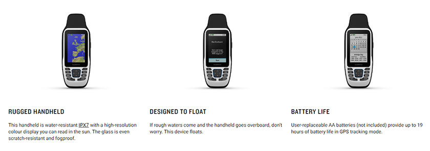
| Battery life | Up to 19 hours |
| Battery type | 2 AA batteries (not included); NiMH or Lithium recommended |
| DIMENSION | 6.77 x 17.40 x 4.23 cm |
| Display resolution | 240 x 400 pixels |
| Display size | 3.8 x 6.3 cm; 3" diag (7.6 cm) |
| Display type | Transflective, 65K color TFT |
| Interface | High-speed micro USB and NMEA 0183 compatible |
| Memory/history | 8 GB |
| MIL-STD-810 | Yes (thermal, shock, water); bare unit only |
| Water rating | IPX7 |
| Weight , | 282g with batteries |
| Sensors | |
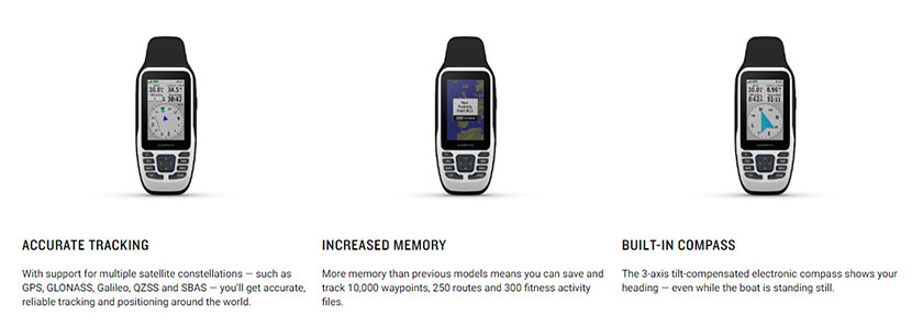
| BEIDOU | Yes |
| Compass | Yes (tilt-compensated 3-axis) |
| GPS | Yes |
| GPS Compass | Yes, (WHILE MOVING) |
| HIGH-SENSITIVITY RECEIVER | Yes |
| QZSS | Yes |
| SBAS | Yes |
| Maps & Memory | |
| Ability to add maps | Yes |
| Basemap | Yes |
| DISPLAYS NATIONAL, STATE/ LOCAL PARKS, FORESTS, WILDERNESS AREAS | Yes (downloadable from Garmin Express™) |
| INCLUDES DETAILED HYDROGRAPHIC FEATURES | Yes (downloadable from Garmin Express™), (COASTLINES, LAKE/RIVER SHORELINES, WETLANDS, AND PERENNIAL AND SEASONAL STREAMS) |
| INCLUDES SEARCHABLE POINTS OF INTERESTS | Yes (downloadable from Garmin Express™), (PARKS, CAMPGROUNDS, SCENIC LOOKOUTS AND PICNIC SITES) |
| MAP SEGMENTS | 15,000 |
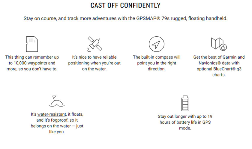
| NAVIGATION ROUTES | 250, 250 points per route; 50 points auto routing |
| NAVIGATION TRACK LOG | 20,000 points, 250 saved gpx tracks, 300 saved fit activities |
| Preloaded maps | Yes |
| RINEX LOGGING | Yes |
| Storage and Power Capacity | Yes (32 GB max microSD™ card, not included) |
| Tracks | 250 |
| Waypoints/favourites/locations | 10,000 |
| Outdoor Recreation Features | |
| Area calculation | Yes |
| Hunt/fish calendar | Yes |
| Point-to-point navigation | Yes |
| Outdoor Features | |
| Automatic routing (turn by turn routing on roads) | Yes, (with optional mapping for detailed roads), FOR OUTDOOR ACTIVITIES |
| Custom maps compatible | Yes |
| Geocaching-friendly | Yes (paperless) |
| Picture viewer | Yes |