- AUTOMOTIVE
- BOATING
-
DIVING
- Bags
- BCDS
- Belts
- Chargers & Batteries
- Cylinders
- Diving Sets
- DPV Scooters
- Dry Boxes
- Fins
- General Accessories
- Instruments
- Knives
- Lifting Bag
- Masks
- Neoprene Accessories
- Regulators & Octopus
- Sets and Combo
- Signaling Buoys
- Snorkels
- Speargun Accessories
- Spearguns
- Suits
- Torches
- Underwater Cameras & Parts
- Underwater Communication Systems
- Watches
- ENGINE
- FISHING
- GARMIN
- INDUSTRIALS
- SOLAR ENERGY
- SPORTS
- SPECIAL OFFERS
- CONTACT US


GPSMAP 585 Plus - 6.0 " - Without Transducer - 010-01711-00 - Garmin
- Brand: Garmin
- Product Code: 010-01711-00
- Availability: Out Of Stock
- $675.68
- Ex Tax: $675.68
Find the perfect place for fishing thanks to the power of Garmin CHIRP technology
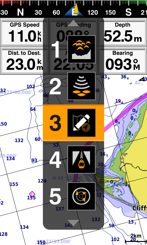
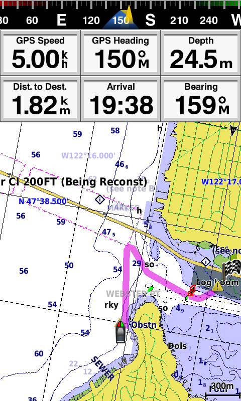
- Bright and clear WVGA color screen diagonal of 6 inches with vertical display mode, keypad and dedicated buttons.
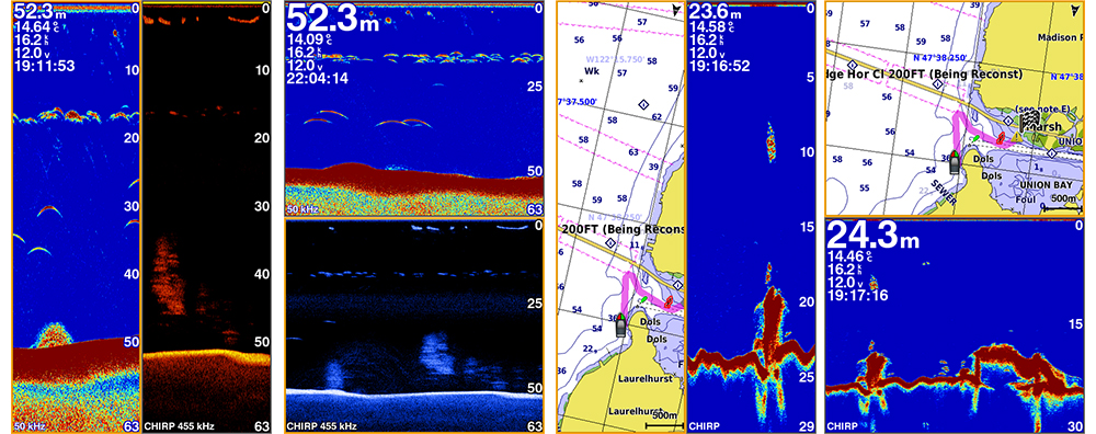
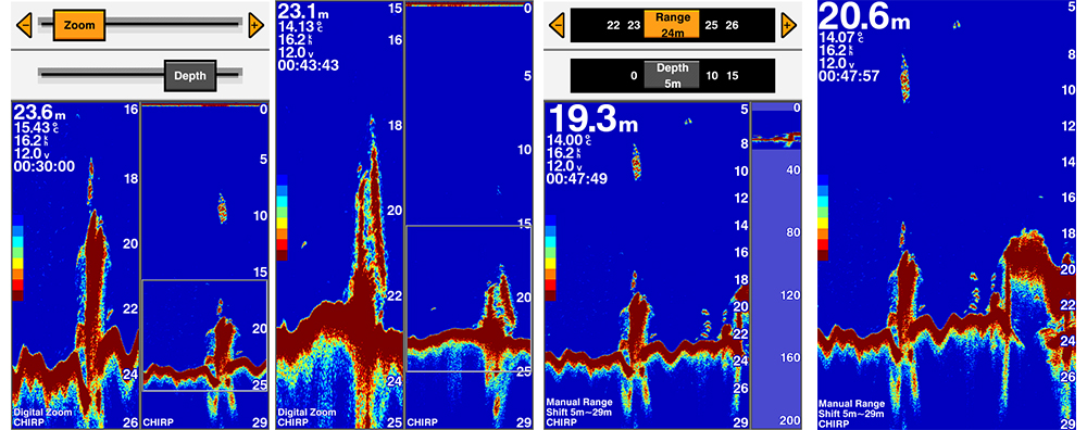
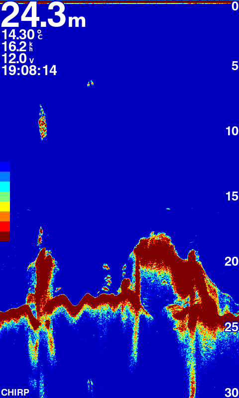
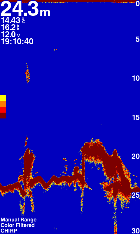
- CHIRP sonar sends a steady beam of frequency ranging from low to high. CHIRP sonar creates sharper fish in the harbor and gives better separation objectives.
- Built CHIRP sonar standard power of 600 watts (RMS) and CHIRP sonar scanning Cleary give almost photographic representation of what is below your boat with detailed images of the object, structure and fish.
- Since it is compatible with powerful GPS, GLONASS and Beidou positioning system, you can easily record up to 12,000 precise points that will take you back to your favorite fishing spot.
- Includes free and intuitive software Quickdraw Contours for the current production of personalized definition of fishing charts.
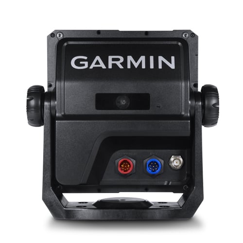
- GPSMAP 585 Plus includes full support for NMEA0183 and RS422 communication interfaces for connection to sensors and accessories from other manufacturers.
- 2 standard slots for SD ™ card enables memory expansion to purchase additional maps, such as HD BlueChart® g2 or BlueChart g2 Vision® HD maps.
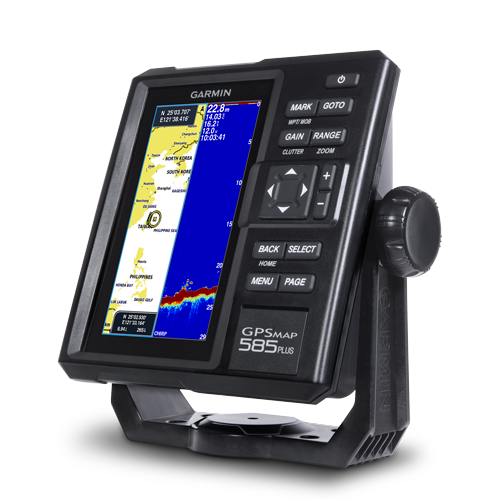
New GPSMAP 585 Plus combo chartplotter and sonar is equipped with a screen 6 inches from the keyboard. Includes multi-language support, and is designed for semi-commercial fishing. GPSMAP 585 Plus is equipped with CHIRP sonar offering great movies in high definition and CHIRP Cleary sonar scanning to provide sharp display of fish in the harbor and provide excellent separation of objectives and a clear picture of the content below the vessel. In addition is characterized by multiple modes of positioning that allow support of powerful systems such as GPS, GLONASS and Beidou. It contains previously installed the new Garmin software Quickdraw ™ Contours with which you can create your own maps with contours of up to 30 cm (1 ft) for each body of water.
Power Garmin CHIRP technology
Sonars which are embedded in the GPSMAP 585 Plus include CHIRP sonar, the most sophisticated sonar technology available to fishermen and boaters. CHIRP sonar gives incredibly clear definition and separation goals because goals enriched with more details than standard sonar. It is equipped with the recording function that coordinates transmission time sonar signal relative to the position of the vessel and stores data in digital form to them with free software for planning HomePort ™ can be played on a computer. With a cable to share user data can easily share points and routes between multiple devices.
The clearest link images obtained by scanning sonar
Garmin CHIRP sonar scanning Cleary gives almost photographic representations of the content below the vessel. Standard Garmin HD-ID ™ sonar and sonar scanning Cleary combined in one multifunction probe.
Support for the best maps of water
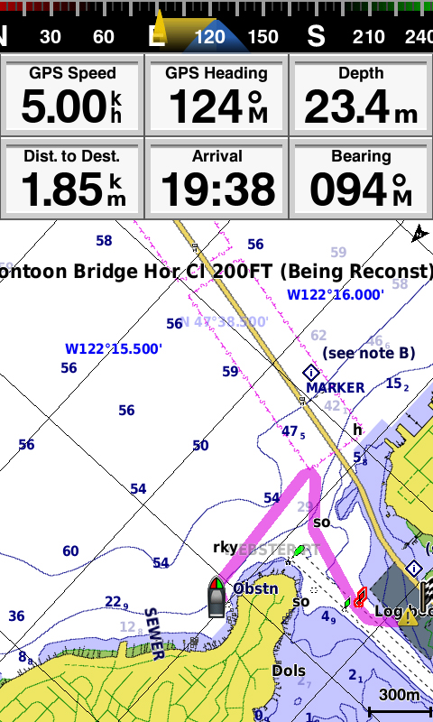
Two standard slots for SD ™ card enables memory expansion to purchase additional maps, such as HD BlueChart® g2 or BlueChart g2 Vision® HD maps. BlueChart g2 Vision HD. They contain exclusive technology Garmin automatic guidance that takes you to your favorite fishing spot. Based on the specifications of your vessel function Auto Guidance instantly creates a visual representation of times that you can follow to avoid shallow water, and other obstacles on the chart.
Software Quickdraw Contours: Create your own maps of high resolution
GPSMAP 585 Plus comes with pre-installed free software Quickdraw Contours that are very easy to use. Using the software, you can now create your own custom fishing map with high-resolution contours of 30 centimeters (1 foot). Make maps to your taste, your are. The data can keep for yourself or share them with Garmin or your friends. It is not necessary experience in mapping, you just go fishing while Quickdraw Contours produces maps. No waiting, and the data do not have anywhere to send as is the case with other software to create maps – results are visible immediately.
Compatible with GPS, GLONASS and Beidou systems
GPSMAP 585 Plus is characterized by multiple modes of positioning that allow support of powerful systems such as GPS, GLONASS and Beidou. Labeling drop to 12,000 precise points and retrieving your best fishing points is quick and easy. Thanks to the huge memory capacity, you can record the point of danger (s) and favorite destinations (points) so you could come back again.
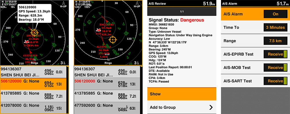
Support for AIS radar
At the same time on the same page, browse the detailed display AIS radar and AIS list. Move the cursor and view the specific items on display radar to display detailed information or drop the VRM / EBL and measure the distance to the window showing the AIS radar. To see the relevant information, you can also select an AIS vessel on the AIS list.
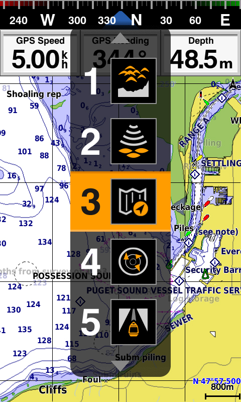
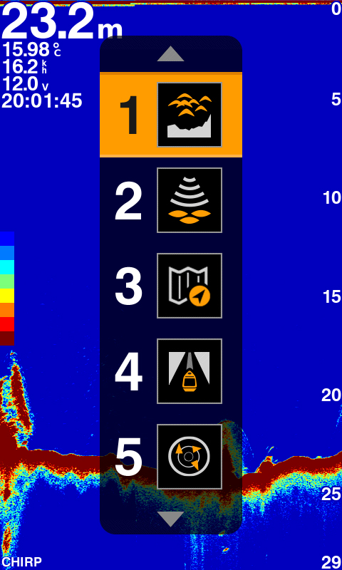
Quickly switch using the PAGE
Quickly and easily switch between functions using the PAGE. Press to move the functions you use frequently or press and hold the button for editing your favorite five pages to view them at any time and can be quickly accessed.
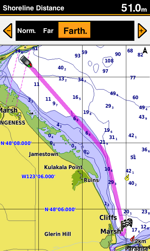
Support for digital zoom and pan zoom
Digital zoom and panning zoom allow you to easily manage the content that you want to display on the screen and areas which want a closer look.
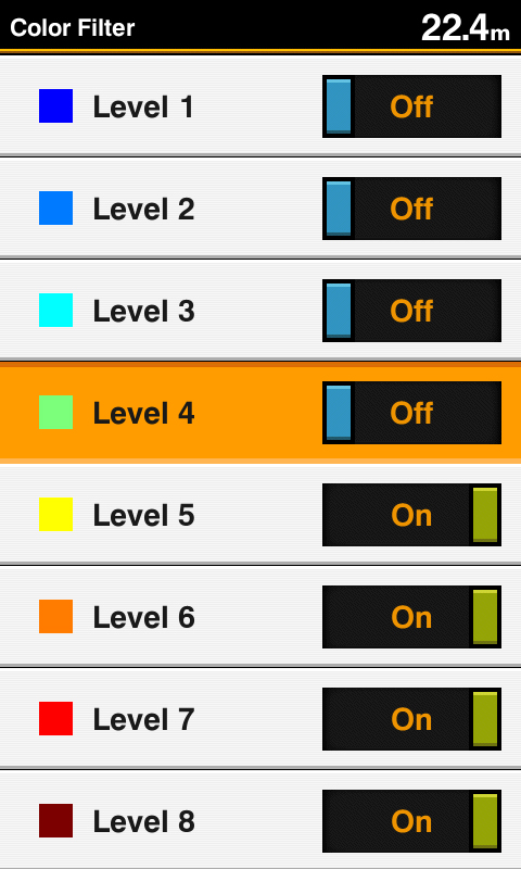
Color filter for display standard sonar
Set up to 8 levels of color to represent different ranges of depth to customize page standard sonar and quickly view the target depth.
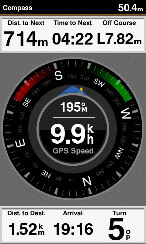
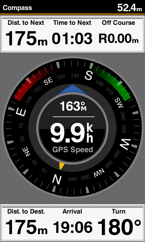
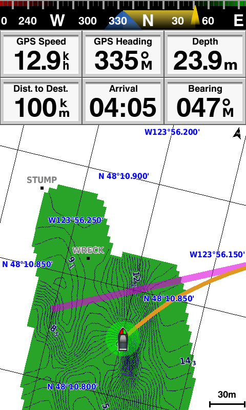
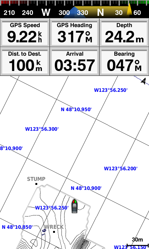
Page Compass allows you a quick overview of the land the course and land speed
Clearly on a single page displays a land speed and direction. Using this information, then you quickly notice that the network is full or not while the vessel towing network, or decide whether to throw the network elsewhere for better results.
Improved automatic guidance
Simply enter the destination and patented technology Garmin automatic guidance will immediately search the relevant maps and display a certain virtual path that helps you on your route avoiding low bridges, shallow water, and other obstacles on the chart.
With the improvement of version 2.0 now have access to even more features and abilities. Adjust calculated route Auto Guidance inserting “via” points or landmarks along the way, or simply browse the approaching danger. Other enhancements from Version 2.0 enables the calculation of the arrival time at any point on the route, but you can not time arrivals to coincide with the opening of bridges and other events that take place at a specific time. From now on, with all states have the option of saving routes automatic guidance for future use so that you are backing up to an SD ™ card with BlueChart g2 Vision or LakeVü HD Ultra kartama¹.
Transfer GPX points
If you are in the GPS product of another manufacturer, or in the Garmin handheld device stored points, clues or frequent route, now easier than ever, you can transfer these items to your new Garmin plotter thanks to standard software GPX format. GPX format is an open standard for exchanging GPS data between platforms and applications. Thanks to the new interface, Garmin principle of “memory of all points” conveys a whole new level of advanced practicality.
IN THE BOX:
GPSMAP 585 Plus
- GPSMAP 585 Plus with a basic world map
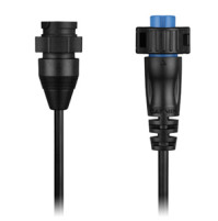
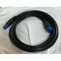
- The power / data cable
- Ring Bearer
- Documentation
| GENERAL | |
| Display resolution | WxH, 480 x 800 pixels |
| Display size | WxH, (72 mm x 136 mm; diagonal 152 mm (diagonal 6.0 ")) |
| Display type | WVGA screen |
| Mounting options | Flush or bracket mount |
| Physical dimensions | 176 mm x 190 mm x 66 mm |
| Power consumption | 7.6 W |
| Weight , | 816 g |
| Chartplotter Features | |
| Garmin Sonar compatible | YES |
| Maps & Memory | |
| Accepts data cards | YES |
| Preloaded maps | The basic world map |
| Routes | 200 |
| Track log | One active trail with up to 50,000 points; 100 saved tracks |
| Waypoints/favorites/locations | 12000 |
| Sonar Features & Specifications | |
| Maximum depth | 2300 ft, fresh water, 1,100 feet, salt water (volume depends on the depth of the bottom and other water conditions) |
| Transmit power | 600 W (RMS) |


Tags: Chartplotter, Fishfinder, Sonar, Control, GLONASS,
Azzi Sport Copyright @2023
Developed by Software Senior