- AUTOMOTIVE
- BOATING
-
DIVING
- Bags
- BCDS
- Belts
- Chargers & Batteries
- Cylinders
- Diving Sets
- DPV Scooters
- Dry Boxes
- Fins
- General Accessories
- Instruments
- Knives
- Lifting Bag
- Masks
- Neoprene Accessories
- Regulators & Octopus
- Sets and Combo
- Signaling Buoys
- Snorkels
- Speargun Accessories
- Spearguns
- Suits
- Torches
- Underwater Cameras & Parts
- Underwater Communication Systems
- Watches
- ENGINE
- FISHING
- GARMIN
- INDUSTRIALS
- SOLAR ENERGY
- SPORTS
- SPECIAL OFFERS
- CONTACT US

echoMAP CHIRP 42dv with Transducer - 010-01562-01 - Garmin
- Brand: Garmin
- Product Code: 010-01562-01
- Availability: Out Of Stock
- $480.18
- Ex Tax: $480.18
The CHIRP technology easier to use
- Color display 4.3 "and keyboard control
- 5Hz GPS receiver integrated that updates the location and direction 5 times per second
- Innovative technology CHIRP
- Technology Garmin DownVü ™
- rotating support bracket / tilting included
- Includes software for creating custom maps HD Quick draw Contours
The new echoMAP CHIRP 42dv comes with a 4.3 "color display with automatic backlight adjustment. The GPS / GLONASS receiver from 5 Hz high-sensitivity updates the direction and position 5 times a second to display the movements of ' boat so fluid and dynamic. echoMAP CHIRP 42dv comes with the innovative function DownVü . it 's easy to install and can be removed from the bracket with a simple gesture.
the difference Garmin CHIRP
The echoMAP CHIRP Series incorporates the best scanning technology available today. Unlike traditional systems which send a single frequency at a time, the CHIRP technology at the same time send a signal on multiple frequencies, from the highest to the lowest, then interpreting the echo of each single frequency. This continuous spectrum provides a greater amount of information CHIRP sonar, which uses them to draw up clearer images and high resolution.
It 'can also record magnify sonar and GPS location here were detected and save them or play them on your computer using the planning software HomePort .
Fishfinder technology DownVü
The DownVü technology uses high frequency to provide a clearer view of the elements present in the vessel producing a more detailed representation of objects, structures and fish. The echoMAP 42dv CHIRP sonar technology combines traditional Garmin HD-ID sonar with that in DownVü scan. The displayed data socioeconomically, synchronized perfectly with the boat's position, can be stored on a microSD support, through Sonar recording function.
Create your own HD maps
Quickdraw Contours is the new totally free feature that allows the most demanding fishermen and ship owners to trace autonomously their bathymetric. The result appears immediately on the screen of your echoMAP CHIRP and can also be shared with other users for free. Sounder HD-ID, transducer compatible with Garmin DownVü or CHIRP transducer compatible with NMEA 2000. You have more depth sounders installed on board? Quickdraw Contours automatically selects the most effective to provide optimal results.
Direction and current position 5 times a second
GPS / GLONASS receiver from 5 Hz high-sensitivity updates the direction and position 5 times a second to display the boat's movements so fluid and dynamic. It allows you to carefully mark up to 5,000 waypoints and select the route to reach the points particularly full of fish.
Bring your echoMAP
The installation cables are connected directly to the bracket. This allows you to quickly install and remove the echoMAP from the support without having to intervene on the links.
Shading of different depths
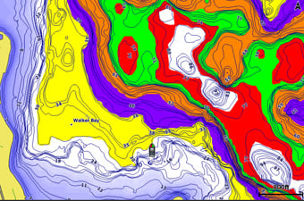
Define up to 10 depth intervals assigning to each a different color. Simplifies the immediate display of the target depth.
Please upgrade to the best maps for boating
The memory is expandable thanks to the microSD ™ card slot. This allows you to install the maps Garmin BlueChart® g2 and BlueChart® g2 Vision ®. BlueChart g2 Vision offers the unique Garmin Auto Guidance feature that guides you directly to where you want instantly creating a route to the vessel specifications, you can follow to avoid the shallow water, and other obstacles on the paper reported.
Auto Guidance optimized
Auto Guidance technology automatically calculates the safest and most reliable route to reach the destination determined by us. The Auto Guidance feature, using the map data, automatically processes the best route and avoid any obstacles along the navigation. From today, this unique feature Garmin offers even more features and functionality in version 2.0. With the Auto Guidance 2.0 you have the option to edit a route, review the most dangerous points, display anywhere on the suggested route, the navigation estimated time; save the planned route. The Auto Guidance 2.0 is included in BlueChart® g2 Vision cartography
GPX waypoint transfer
If you have waypoints, tracks or routes stored on the GPS of another manufacturer or on a portable Garmin device, it is now easier than ever to import them to your new Garmin plotter, using the data in GPX format.The GPX format is an open standard support for the exchange of GPS data between different platforms and applications. With this development, you are guaranteed that all important data stored on an old tool are maintained and transferred to your new Garmin device.
¹BlueChart g2 Vision SD card & nsp; required for this technology.
IN THE BOX:
Version with transducer
- echoMAP CHIRP 42dv
- power / data cable
- Quick release support
- GT20-TM transducer (4-pin)
- Brackets for installation at the stern or electric motor
- Fast guide
sensorless version
- echoMAP CHIRP 42dv
- power / data cable
- Quick release support
- Cable with eco 4-pin to 8-pin transducer adapter
- Fast guide
| Appearance and performance | |
| Antenna | Internal or external over NMEA 0183 |
| Display Resolution, WxH | 480 x 272 pixels |
| energy consumption | 7W |
| Garmin Marine Network ™ ports | None |
| Mounting Options | On bracket or flush |
| NMEA 0183 compatible | Yup |
| physical dimensions | 10.2 x 16.8 x 4.6 cm |
| Screen size, WxH | 2.1 "x 3.7", 4.3 "diagonal (5.4 x 9.5 cm, 10.5 cm diagonal) |
| Screen Type | WQVGA screen |
| Water resistance classification | IPX7 |
| Weight | 0.7 kg (1.6 lbs) |
| Chartplotter Features | |
| BlueChart® Mobile (planning) compatible | Yup |
| Compatible with Garmin sounder module | Yup |
| Garmin Helm compatible | Yup |
| Supports AIS (tracks target ships position) | Yup |
| Supports DSC (displays position data from DSC-capable VHF radio) | Yup |
| Tide tables | Yup |
| Maps & Memory | |
| Accepts data cards | 1 microSD ™ card |
| Preloaded maps | None |
| storable paths | 100 |
| Track log | 50,000 points; 50 saved tracks |
| Waypoints | 5,000 |
| Connections | |
| NMEA 0183 input ports | 1 |
| NMEA 0183 output ports | 1 |
| Transducer pin numbers | 4 |
| Video input ports | Nobody |
| Video output ports | Nobody |
| Wireless connectivity | YES |
| Sonar Features & Specifications | |
| Bottom lock (shows return from the bottom up ) | Yup |
| CHIRP sonar technology | Yes (Built-in) |
| DownVü™ | Yes (integrated) |
| Dual-frequency sonar | Yup |
| Frequencies supported | CHIRP (low, mid, high) Traditional: 50/77/200 kHz DownVü: 260/455/800 kHz |
| Log and graph of the water temperature | Yup |
| Maximum depth | 2,300 feet at 77 kHz, freshwater 1,100 feet at 77 kHz, saltwater (The depth of capacity depends on the type of bottom and from other water conditions) |
| SideVü™ | YES |
| Sonar double cone | Yup |
| Sonar history rewind | Yup |
| Sonar recording | Yup |
| Transmission power | 500 W (RMS) / 4,000 W (peak to peak) |
Tags: Chartplotter, Fishfinder, Sonar, Control, GLONASS,
Azzi Sport Copyright @2023
Developed by Software Senior