- AUTOMOTIVE
- BOATING
-
DIVING
- Bags
- BCDS
- Belts
- Chargers & Batteries
- Cylinders
- Diving Sets
- DPV Scooters
- Dry Boxes
- Fins
- General Accessories
- Instruments
- Knives
- Lifting Bag
- Masks
- Neoprene Accessories
- Regulators & Octopus
- Sets and Combo
- Signaling Buoys
- Snorkels
- Speargun Accessories
- Spearguns
- Suits
- Torches
- Underwater Cameras & Parts
- Underwater Communication Systems
- Watches
- ENGINE
- FISHING
- GARMIN
- INDUSTRIALS
- SOLAR ENERGY
- SPORTS
- SPECIAL OFFERS
- CONTACT US


Montana 710 - Rugged GPS Touchscreen Handheld - 010-02963-01 - Garmin
- Brand: Garmin
- Product Code: 010-02963-01
- Availability: Out Of Stock
- $719.82
- Ex Tax: $719.82
Montana 710 - Rugged GPS Touchscreen Handheld - 010-02963-01 - Garmin
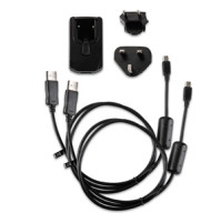
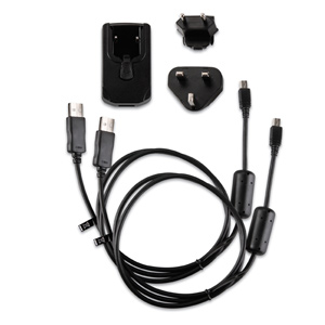
IN THE BOX:
- Montana® 710
- High capacity lithium-ion battery pack
- USB cable (USB-C to USB-C)
- Documentation
| Security information | |
| SECURITY UPDATES UNTIL AT LEAST (YYYY-MM-DD) | 2027-01-08 |
| GENERAL | |
| Battery life | GPS Mode: up to 24 hours Expedition Mode: up to 440 hours Powered Off: up to 1 year Note – Battery life estimates are with full sky view and can be significantly impacted by obstructions or tree cover. |
| Battery type | Rechargeable lithium-ion (included) |
| DIMENSION | 8.76 x 18.30 x 3.27 cm (3.5″ x 7.2″ x 1.3″) |
| Display resolution | 480 x 800 pixels |
| Display size | 6.48 x 10.80 cm (2.55″W x 4.25″H); 12.70 cm (5″ diag) |
| Display type | WVGA transflective, dual orientation |
| Interface | USB-C |
| Lens material: | Chemically strengthened glass |
| Memory/history | 32 GB (user space varies based on included mapping) |
| MIL-STD-810 | Yes (thermal, shock, water, vibe) |
| Touchscreen | Yes |
| Water rating | IPX7 |
| WEIGHT | 410g (14.5oz) with included lithium-ion battery pack |
| Sensors | |
| Barometric altimeter | Yes |
| Compass | Yes (tilt-compensated 3-axis) |
| Galileo | Yes |
| GLONASS | Yes |
| GPS | Yes |
| GPS Compass | Yes |
| HIGH-SENSITIVITY RECEIVER | Yes |
| Maps & Memory | |
| Ability to add maps | Yes |
| AUTOMATIC ROUTING | Yes |
| Basemap | Yes |
| Course preview (see detailed, hole-by-hole preview) | 250, 200 course points per course |
| DISPLAYS NATIONAL, STATE/ LOCAL PARKS, FORESTS, WILDERNESS AREAS | Yes |
| INCLUDES DETAILED HYDROGRAPHIC FEATURES | Yes |
| INCLUDES SEARCHABLE POINTS OF INTERESTS | Yes |
| MAP SEGMENTS | 15 000 |
| NAVIGATION ROUTES | 250, 250 points per route; 50 points auto routing |
| NAVIGATION TRACK LOG | 20,000 points, 250 saved gpx tracks, 300 saved fit activities |
| Preloaded maps | Yes (TopoActive Europe - Additional regions can be downloaded over Wi-Fi®) |
| RINEX LOGGING | Yes |
| SATELLITE IMAGERY | Yes (direct to device) |
| Storage and Power Capacity | Yes (32 GB max microSD™ card) |
| TRACK POINTS | 250 |
| Waypoints/favourites/locations | 10 000 |
| Connections | |
| Wireless connectivity | Yes (Wi-Fi®, BLUETOOTH®, ANT+®) |
Tags: Montana GPS, handheld GPS,
Azzi Sport Copyright @2023
Developed by Software Senior
